
Selected Hikes from Milt McAuley
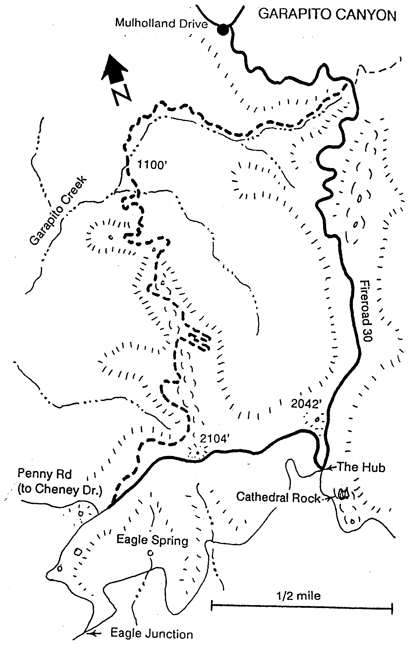
GARAPITO CANYON LOOP
(by way of Fireroad 30 from Gateway Park)
The following is reprinted by permission of the author, Milt McAuley. You can discover more hikes like this in his books on the Santa Monica Mountains. Milt passed away in 2008 but his impact lives on! Remember to always: contact park agency for area specifics, practice the "buddy system", consult a map, wear appropriate clothing, take extra water, and don't disturb or remove anything. Did we mention, Enjoy Yourself!
Maps: SMMTS, East
Distance: 7-1/2 miles roundtrip
Elevation: 1300' loss and gain
Time: 4 hours
Trailhead: Mulholland Drive
Garapito Canyon is steep, rugged and beautiful. Sierra Club volunteers began building a trail from Fireroad 30 in 1985 and
completed it in 1987.
Go to the Marvin Braude Mulholland Gateway Park at
the south end of Reseda Boulevard. Hike uphill from the Park on a dirt road to
turn right onto a narrow trail that contours up to Mulholland Drive. Turn right
and hike to Fireroad 30. Walk around the fireroad gate and go 1/2 mile to a
point where some power lines cross. The trail into upper Garapito Canyon is on
the right and begins here.
Cross a small meadow then abruptly enter dense chaparral. The entire canyon last burned in 1961 and the chaparral has had time to fully recover. Trail building in 1985 opened sunlit corridors so that dormant seeds that have lain in the duff since the 1961 fire recovery period could sprout. The spring of 1986 ushered in a riot of Giant Phacelia, Mustard Evening Primrose, Contorted Evening Primrose, White Pincushion, Yellow Monkey Flower, and other fire-following plants along the trail.
In the more than 500 feet of elevation loss, the trail takes us through a lot of Chaparral and occasional patches of Coastal Sage Scrub. Whenever we are near the streambed we will see Sycamore, and at once place several Cottonwoods. Geologically, the streambed and ravines are the Coal Canyon Formation, a marine sequence of sandstone, siltstone, and pebbly conglomerate that was laid down during late Paleocene and Eocene times, 60-50 million years ago. The trail crosses the main streambed, goes up and around a shoulder, and back down to a stretch along the stream to an oak grove. At this point we have walked about 2-3/4 miles from the trailhead -- take a rest -- we are about to start uphill, gaining 700 feet in the next mile and a half. A massive buttress, or ridge, drops down from Peak 2104 to our present location in the canyon. The trail works its way up the ridge at a comfortable walking grade, making switchbacks as it goes. Along one section of the lower trail we look across an arroyo at a spectacular conglomerate cliff. Later on after a couple of switchbacks, we find ourselves above and near the edge of the cliff. This hike offers lots of excuses to stop and rest. The panorama below unrolls continuously as we climb through the most dense mature Chaparral in the area. (I was going to say "in the world" but that may not be true.) We continue upward and get an idea that the crest is near when we go through some open spaces of California Buckwheat.
Upon reaching Eagle Spring Loop road, turn left. We might elect to go on a short side trip to the top of Eagle Rock from this point. If so we turn right, walk slightly uphill 650 feet, then walk over a rise on the east and climb the backside of Eagle Rock. The view of Santa Ynez Canyon, to the south, and the ocean is dramatic. The fireroad toward Trippet Ranch and East Topanga Fireroad are visible and so is more of the southern half of the Park. Look for Silver Lotus plants in bloom from March through June, growing in cracks in the sandstone of Eagle Rock.
The route out is east to the "Hub," about 1 mile from where Penny Road intersects Eagle Spring Loop road. Enroute we pass the highest point on today's hike near Peak 2104. Look at the road near the peak; the pattern of the rock is caused by the slow cooling of molten lava as it intruded through cracks into the sandstone about 15 million years ago. This lava is called diabase --- we've given it the common name "Onion Rock" because it exfoliates concentrically somewhat like an onion would. At the "Hub," turn left and walk 2-1/2 miles to our cars at the Gateway Park.
P.O. BOX 345
Agoura Hills, CA 91376
Email: mail@smmtc.org
Phone: 805-885-7224
SMMTC is a volunteer, tax deductible,nonprofit 501(c)(3) charitable organization
Tax ID: 95-3911604